


Fireguard Wildfire Tracker
4.4182.00 Reviews
App Specs
- Version
- 10.0.15
- Updated On
- License
- Free
- Downloads
- 100,000+
- Developer
- Qvyshift LLC
- Categories
- Weather
- Platform
- Android
Screenshots
 Analysis by AppCompare
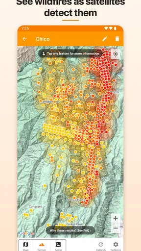
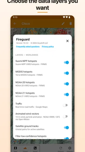
When wildfire smoke becomes part of the daily weather conversation, a normal forecast app can feel incomplete. I found Fireguard Wildfire Tracker useful because it focuses on a different question: where active fires are being detected around the world, and how that information can help me think about travel, outdoor plans, and household safety. It is a free weather app from Qvyshift LLC, built around NASA active fire data rather than a general mix of forecasts, radar, and hourly temperature charts.
That narrow purpose is both its appeal and its main limitation. I would not install it as my only weather tool, because it is not a replacement for local forecasts, official emergency alerts, air-quality readings, or evacuation instructions. I would install it beside those tools if wildfire awareness mattered to me. In my experience, its value comes from giving fire activity a dedicated place on the screen instead of making me search through a broad weather service every time smoke or a nearby blaze becomes a concern.
How Fireguard fits into a shared household routine
The most convincing use case is a household where several people make decisions based on the same regional conditions. Imagine one person checking whether a weekend drive passes near active fire detections while another is deciding whether to take children to a park. A third household member may simply want a quick visual reference before opening windows or planning an outdoor chore. Fireguard can support that shared conversation by putting wildfire activity at the center of attention.
I like this kind of focused app because it changes the question from “What is the weather?” to “Is fire activity relevant to what we are doing?” Those are not the same question. A sunny forecast does not mean a nearby area is unaffected by smoke, and a general weather app may bury fire information among many other panels. Fireguard makes the wildfire layer the reason to open the app, which is helpful when that is the information I need most.
Still, a shared device can create false confidence if everyone treats the map as a complete safety picture. Active fire detections are valuable for awareness, but they should not become the household’s only source of truth. Before changing plans because of a serious threat, I would check local authorities, emergency notifications, road information, and air-quality guidance. The app works best as an early-awareness and context tool, not as an evacuation command center.
There is also a practical household advantage to a dedicated tracker: it gives family members a common reference point without requiring one person to explain every development from memory. If someone asks whether a fire is “near us,” I can use the app to begin that conversation, then verify the meaning through official local sources. That two-step habit is more responsible than forwarding a screenshot and assuming the picture answers every safety question.
What I would use it for day to day
My favorite routine is a quick check before making plans that involve distance. If I were driving to a rural area, visiting relatives, arranging a hike, or planning outdoor work, I would look at Fireguard before leaving. I would not use that glance to declare a route safe. Instead, I would use it to identify whether wildfire activity deserves a closer look and whether I should spend another minute checking local information.
Worth Reading Before You Choose

EA SPORTS FC Mobile 26 Is a Bigger Football Game, but It Takes Time

Flipboard Shows What News Apps Must Do Beyond the Feed

Switching to Android Auto Means Rethinking Your Driving Routine

Google Calendar Makes a Crowded Week Easier to Manage

Ludo King Makes the Most of the Minutes Between Plans

Baby Panda World Brings Quick Play to Modern Phones, but Its Game Library Feels Busy
This is especially useful when different people in a home have different levels of awareness. One person may follow fire news closely, while another may not notice a developing situation until smoke is visible. A focused map can make the topic easier to discuss. It can also help someone who is unfamiliar with a region understand that a distant-looking destination may still need checking before a trip.
A less obvious benefit is planning around uncertainty rather than reacting to headlines. News reports often emphasize the most dramatic incident, while a global active-fire view can encourage me to look at the broader pattern of fire activity. That does not automatically tell me which event is dangerous or which one affects my address, but it helps me ask better follow-up questions instead of relying on a single headline.
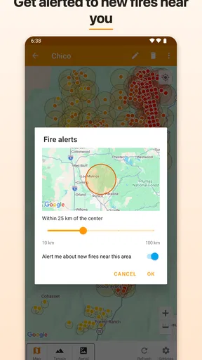
I would avoid opening it repeatedly as a substitute for an alert system. A tracker is useful when I choose to inspect it, while alerts and official notices are designed to reach me when I am not looking. That distinction matters in a household: the person who checks the app most often should not become the only person responsible for noticing a change.
Setting boundaries before more than one person uses it
Before placing Fireguard on a shared tablet or family phone, I would agree on what the app is for. My boundary would be simple: use it to spot active-fire information and guide further checking, but do not treat it as permission to enter an area, ignore an order, or delay contacting emergency services. That small agreement prevents a map from carrying more authority than it should.
The app is suitable for Everyone, which makes it approachable in a household with mixed ages. That rating does not remove the need for adult context during a real emergency. A child can learn what the map is showing, but an adult should explain that a detection marker is not the same thing as a confirmed threat to the home, a road closure, or an evacuation notice.
I would also keep account expectations clear. Fireguard is not something I would present as a family-management platform. I would not assume that installing it on one device automatically creates shared profiles, synchronized household decisions, or separate permissions for each person. If several people use the same device, the household should decide who checks it and how important findings are confirmed elsewhere.
That matters most when a phone is passed between people. One user may zoom into a distant region, while another later opens the app expecting a local view. Without a shared habit, the second person may misunderstand what is on screen. I would make a quick verbal note—“this is showing the area near our trip, not our neighborhood”—rather than relying on the next user to infer the context.
For a family with older relatives or occasional guests, I would keep the explanation practical. Show what the app is meant to reveal, explain that NASA active fire data is the foundation, and then name the sources that must be checked for immediate action. The goal is not to turn everyone into a wildfire analyst. It is to make sure a useful visualization does not become a confusing or alarming object on a shared screen.
Coordinating plans without turning the map into a verdict
Fireguard becomes more useful when it is part of a repeatable coordination workflow. My version would be: check the app, identify whether a relevant area has active-fire detections, verify the situation through local official information, and then tell the household what decision has actually been made. That last step is easy to overlook. “There is activity on the map” is information; “we are postponing the trip” is a household decision.
This workflow is particularly helpful for travel. Suppose one family member is already on the road and another is still at home. The person at home can inspect the broad fire picture, but should avoid giving route instructions based only on the map. Instead, they can ask the traveler to check current road conditions and official notices. Fireguard can prompt coordination without pretending to provide every piece of information needed for a safe journey.
Another useful habit is to record the time of a check in ordinary conversation: “I looked before lunch, and now we are checking again because the wind changed.” I am not suggesting that the app itself provides a complete timeline or prediction system. The point is that wildfire information can change, and a household should not confuse an earlier glance with a current assessment.
There is a trade-off here. A global view can broaden awareness, but it may also introduce more information than a household needs for a local decision. If I only care about the few miles around my home, I would pair Fireguard with a source designed for local alerts and air quality. If I am comparing regions, planning a long drive, or trying to understand fire activity beyond my immediate area, its wider scope becomes more useful.
I also would not use it to settle arguments about whether smoke is safe. Smoke exposure depends on local conditions and personal circumstances, and a fire marker alone cannot answer that question. In a household with asthma, young children, older adults, or other vulnerabilities, I would put health guidance and official air-quality information ahead of any conclusion drawn from the map.
Age, trust, and explaining what the data means
The Everyone rating is a reasonable fit for the app’s subject matter, but I think trust depends more on explanation than on age labels. A young user may see a cluster of markers and assume every one represents an immediate emergency. An older user may assume a quiet-looking area is completely safe. Both interpretations can be wrong without context.
I would describe the app as a way to notice where active fire detections are being reported, not as a guarantee that every fire is visible or that every visible detection threatens people. That wording is important. It respects the usefulness of NASA data while keeping expectations realistic. It also gives children and less technical family members a clear reason to verify important information through local authorities.
Trust is easier to maintain when adults admit what the app can and cannot decide. I would be comfortable telling a teenager to use it while researching a travel destination, but I would not ask them to make an emergency decision for the household from the screen alone. Likewise, I would encourage an older relative to open it for awareness while making sure they know where official instructions come from.
Privacy and account boundaries are another reason not to overstate what this app does. I would treat it as a shared information tool, not as a way to monitor family members or coordinate their locations. If the household needs check-ins, location sharing, or emergency communication, those needs belong to other tools and clear family agreements. Fireguard’s role is narrower, and that narrowness is healthier than expecting one app to manage every safety problem.
For a child using a shared tablet, I would keep the routine calm and educational: look at the map together, discuss distance and uncertainty, and explain that adults verify serious concerns. For a household with no children, the same principle applies to guests or relatives who are unfamiliar with wildfire maps. A minute of context can prevent unnecessary panic and reduce the chance that someone dismisses a meaningful signal because it looks abstract.
Performance expectations and the cost of keeping it around
Fireguard is free to download, which removes the biggest barrier to trying it as a secondary weather tool. Its listed in-app purchases are $9.99 per item, so I would review any purchase screen carefully before assuming every function is included at no cost. I would not choose it based on the promise of avoiding all other weather services; I would choose it because the core idea is focused enough to complement them.
The current version is 10.0.15, and the minimum operating system is Android 7.0. That makes it accessible to many older Android devices, which is useful for a shared household phone that is no longer the newest model. I would still test it on the actual device intended for family use, especially if that device has a small display or limited performance. A map can be harder to interpret on a cramped screen than on a tablet.
Its audience appears established rather than experimental: the app has over one hundred thousand installs, an average rating of 4.4 from around 4.8 thousand ratings, and 182 written reviews. Those figures make me more comfortable recommending a trial, but they do not change my advice about verification. Popularity can show that people find a tool useful; it cannot turn a general-purpose tracker into an official emergency service.
The release date of June 14, 2018 also gives the product a longer history than a brand-new utility. I see that as a positive when considering whether an app has had time to mature, but I would still keep normal app-maintenance habits: update it when appropriate, check that it opens correctly before a trip, and avoid waiting until a crisis to learn how its map is organized.
One practical tip is to install it before wildfire season or before traveling, then explore it when there is no immediate pressure. On a shared device, this lets each regular user learn the visual layout and agree on what counts as a reason to verify information. That preparation is more valuable than downloading any safety app in the middle of a stressful event.
Where it beats ordinary weather apps—and where it does not
Compared with a standard weather app, Fireguard has a sharper identity. Ordinary weather tools are better for hourly forecasts, rain timing, temperature, wind, and everyday planning. Fireguard is better when I want wildfire activity to be the first thing I investigate. That specialization saves time when fire is the subject, but it means I still need another service for the rest of the forecast picture.
Compared with news apps, it offers a more visual and less editorial starting point. News can explain impact, response, and local consequences, while a tracker helps me see geographic context. I would use both when the situation matters: Fireguard to orient myself, reputable local reporting and authorities to understand what people should actually do.
Compared with official emergency tools, it is less suitable for direct instructions. Official sources should win whenever there is an evacuation order, road restriction, shelter guidance, or urgent health advice. The app’s strength is that it can make me aware of a fire-related question before I have all the answers. Its weakness is that awareness alone is not enough for a high-stakes decision.
Compared with air-quality apps, it answers a different question. Fire activity may help explain why smoke is present, but it does not replace particulate readings or health recommendations. I would use Fireguard to understand possible source areas and an air-quality service to decide whether outdoor exposure is sensible.
That division of labor is the key trade-off. If someone wants one app that predicts weather, measures air quality, issues local emergency alerts, provides road closures, and tracks fires globally, this is not the right choice. If someone already has those needs covered and wants a dedicated wildfire view, Fireguard makes more sense and avoids forcing a general weather app to do a job it was not designed to emphasize.
Who should install it and who should skip it
I would recommend Fireguard to people who live in or travel through wildfire-prone regions, households that regularly plan outdoor activities, and anyone who wants a global perspective on active fire detections. It is also a sensible secondary app for families that need a shared starting point for conversations about smoke, travel, and changing conditions.
I would be more cautious recommending it to someone who rarely encounters wildfire concerns and only wants a daily forecast. That person may find a conventional weather app more convenient because it puts temperature, precipitation, and wind in one place. Fireguard’s focused design is useful only when its focus matches the user’s questions.
I would also advise against relying on it alone for emergency preparedness. A household should know its local alert channels, keep essential contacts available, and understand where official instructions appear. Fireguard can fit into that plan, but it should not be the plan itself. Anyone who feels anxious when seeing broad fire activity may prefer a local official source that provides clearer action-oriented information.
For shared use, the best audience is a household willing to agree on boundaries. Adults should handle urgent interpretation, everyone should know that the map is not an evacuation order, and important decisions should be confirmed through appropriate local sources. Those habits make the app more useful without asking it to become something it is not.
My household verdict
After using Fireguard as a dedicated wildfire-awareness tool, I see it as a worthwhile free companion rather than a complete weather solution. Its connection to NASA active fire data gives the app a clear purpose, and its global scope can add context that ordinary forecast apps often lack. I especially appreciate how it can start a practical household conversation before a trip or outdoor plan.
My recommendation comes with a firm condition: keep the boundaries visible. Use the app to notice, compare, and ask better questions. Do not use a marker by itself to decide whether a road is open, whether a home is safe, or whether smoke exposure is harmless. Those decisions require current local information and, when necessary, professional guidance.
For a shared device, I would install it, explain its role to everyone who might open it, and pair it with a normal weather source, an air-quality source, and official emergency channels. That combination respects both the app’s strength and its limits. Fireguard is most valuable when it turns wildfire awareness into a verified household conversation, not when it is treated as the final authority.
In short, I would recommend it to a friend who wants a focused view of wildfire activity and understands the difference between detection, risk, and instruction. I would skip it as a sole weather app, and I would never let its presence replace local emergency guidance. Used with that judgment, Fireguard Wildfire Tracker earns its place on an Android device as a specialized, practical addition for people who want fire activity to be easier to monitor.
Pros
- Live wildfire alerts help users monitor nearby threats quickly.
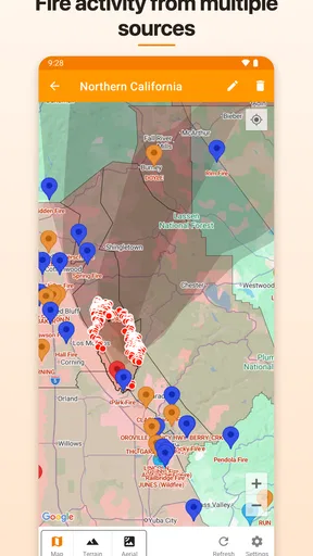
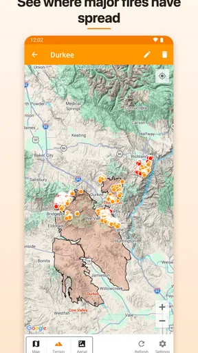
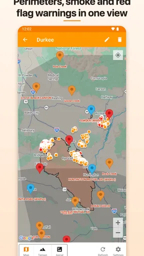
- Interactive maps make it easy to understand fire locations and spread.
- Useful for planning travel
- evacuations
- and outdoor activities.
- Covers multiple regions with regularly updated incident information.
- Simple interface lets users check wildfire activity at a glance.
Cons
- Coverage and alert quality can vary significantly by location.
- Some incidents may appear with delays during rapidly changing events.
- Requires location access for the most relevant local notifications.
- Map details may be limited for smaller or remote fires.
- Frequent alerts can become overwhelming during severe fire seasons.
FAQs for Fireguard Wildfire Tracker
What is Fireguard Wildfire Tracker, and what does it do?
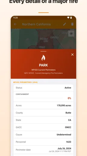
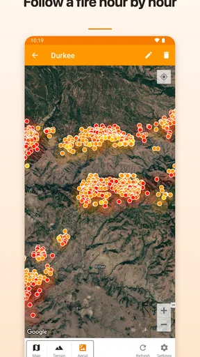
Fireguard Wildfire Tracker is designed to help users monitor wildfire activity and stay informed about potential threats. It typically presents fire locations, perimeters, alerts, and related information on an interactive map. After reviewing the app, its main value is quick access to situational awareness, although users should treat it as an information tool rather than a replacement for official emergency instructions.
Does Fireguard Wildfire Tracker provide real-time wildfire alerts?
The app may display recently reported incidents and send notifications when supported by its data sources and your device settings. However, the speed and accuracy of alerts can vary depending on reporting agencies, network availability, location permissions, and update intervals. Before relying on notifications, enable alerts correctly and confirm important information through local emergency services, fire departments, or government warning systems.
Can I use Fireguard Wildfire Tracker to check fires near my location?
Yes, location-based viewing is one of the most useful features for checking nearby wildfire activity. You may need to grant permission for the app to access your approximate or precise location, depending on how its map works. The displayed distance or risk should be interpreted carefully, because wind, terrain, road closures, and changing fire conditions can make a situation more dangerous than the map initially suggests.
Does Fireguard Wildfire Tracker work without an internet connection?
The app generally depends on an internet connection to download current wildfire reports, map data, satellite information, and alerts. Some previously loaded map content may remain visible temporarily, but offline information should not be considered current. If you are traveling through an area with weak coverage, download official emergency resources where possible and keep alternative ways to receive evacuation instructions.
Is Fireguard Wildfire Tracker accurate enough for emergency decisions?
Fireguard Wildfire Tracker can be useful for following developing incidents, comparing fire locations, and understanding general conditions, but no tracking app should be your only source during an emergency. Data can be delayed, incomplete, or affected by technical limitations. Always follow evacuation orders and instructions from local authorities, and verify critical information through official emergency channels before making safety-related decisions.


